

This is a guest post from BillInLaurelMD on the state of ice conditions in the Arctic.
This is the next in an occasional series of diaries on the state of Northern Hemisphere Arctic sea ice (and other topics as warranted), written in memory of Johnny Rook, who passed away in early 2009. He was the author of the Climaticide Chronicles.
December 26 we lost our snow cover after a week with at least 7″ on the ground. But the storm that plagued the Midwest and South Central U.S. pulled in mild air from the southeast into the Mid-Atlantic states; Christmas afternoon through Saturday noon featured rain and fog; the fog resulting from mild moist air in contact with cold snow pack. And that fog was quite the snoweater; as water vapor changes to water droplets, heat is released which rapidly increases the melt rate of the snowcover.
There have been many days recently featuring gloomy greyness with an active southern storm track resulting in greater than usual rainfall, snowfall, and cloud along the southern tier of the U.S. and up the Atlantic coast. This is common with moderate to strong El Niño events in these areas. The recent storm in the Midwest was not your typical El Niño pattern storm at all, however.
The story from the Arctic follows.
When the picture below was taken, it had just stopped snowing in the previous hour in Nome, AK. The hourly readings were:
Temperature: 30°F; Dewpoint: 24°F; Winds: East at 13 kts; Weather: Overcast.

December to date at Nome has been 5.1°F above normal, with one brief cold snap I discussed in my solstice diary. This has also been true over much of the rest of AK except for from Anchorage AK through the southeastern panhandle, where temperatures were near to slightly below normal. Barrow AK has run +7.1°F. Kotzebue AK (north of Nome toward the Arctic Ocean) has been +9.8°F. Fairbanks AK: +4.4°F. McGrath AK (west-central interior): +2.5°F. King Salmon AK (extreme southwest mainland): +4.3°F. Bethel AK (southwest coastal mainland): +6.9°F. Cold Bay AK (Aleutians): +3.0°F.
A more general analysis of the Arctic for the first 27 days of December 2009 appears in the graphic below, courtesy of the National Oceanographic and Atmospheric Administration (NOAA) Earth Systems Research Lab (ESRL). The land mass of Asia has been quite cold, but the Arctic basin has been almost univerally warmer than normal, as much as +15°C above normal north of where the cold weather has been in Siberia. I’ll show below that this corresponds to an area of below normal (actually, NO) sea ice cover where normally there should be some. Strong positive temperature anomalies can be found in the Arctic basin from about 150°E eastward north of Alaska and Canada across to Greenland.

Arctic Sea Ice Extent, 26 December 2009
Arctic sea ice extent, if you’ve been following my diaries, is estimated by at least two different organizations using slightly different algorithms to decipher the microwave satellite data to determine sea ice coverage from Polar Orbiting Environmental Satellites. The joint project betweeen the Japan Aerospace Exploration Administration and the International Arctic Research Center (Fairbanks, AK) keeps a daily record of sea ice extent and plots the data from 2002 to present in overlapping time series. That graphic is below, with 26 December 2009 annotated.

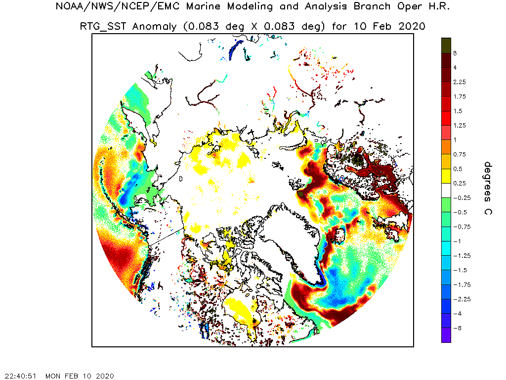
Even with all the cold weather recently in the middle latitudes, particularly in Europe and North America (and apparently Siberia as well, away from the Arctic coastline), Arctic sea ice formation is about as low as it has been at this point in the cold season over the last 8 years. This is at least partly the result of all the heat stored up in the ocean in regions with below average sea ice cover last summer. Sea Surface Temperatures (SSTs) are still above normal in the areas with less than normal (or NO) sea ice, as can be seen at the National Centers for Environmental Prediction’s Marine Modeling and Analysis Branch data for the Arctic Ocean.
As can be seen in the graphics below, these regions are mainly over the Labrador and Barents Seas, along with the southern part of the Davis Strait between Greenland and Baffin Island in Canada.

Along with the extent, we can also look at the NSIDC concentration. This is below. I’ve highlighted areas with relatively low concentrations that may be susceptible to ice loss from wave and/or wind action.

Now let’s look at the December 2009 sea level pressure anomalies and the resulting anomalous winds, shown in the graphic below.

Winds blow at 15-45° angle from the lines of constant pressure, from high to low pressure (depending on the amount of friction). The winds generally over the Barents and Labrador Seas are blowing ice away from the ice pack. This tends to push it into warmer water where the ice will melt.
Projection for mean December 2009 Arctic Sea Ice Extent
Below you’ll find the graphic from the NSIDC for Arctic sea ice extent from 1 Sept through 31 Jan for 2007-08, the mean for 1979-2000, and the current refreeze season through 26 December. On the graphic, I show assumptions for projecting the data through the end of the month, and an estimate of the resulting mean December 2009 sea ice extent in the Northern Hemisphere.

I took the resulting estimate and tacked it onto the mean December 1979-2008 time series of Arctic sea ice extent to see about where we’d wind up this year. The result is below.

As you can see, the downward trend is expected to continue unabated; note that the estimate for this month lies a bit below the 1979-2008 trend line.
What Comes Next?
What comes next depends on a number of factors. The weather in the North Pacific has been dominated by strong cyclones which have advected warm air from the extratropics into AK on and off, and subsequently into the Arctic region. This is likely the result of the ongoing moderate El Niño. The current El Niño is showing no signs currently of weakening; the last week or two in fact, the sea surface temperature anomalies actually have increased slightly. The current event is now almost as strong as the one in 2002-03.
Will that mean storminess in the North Pacific will continue? Probably so; but each El Niño has its own character and often contains some surprises; a storm like the one from TX to MN Christmas weekend is not that typical, for example. Nor is the cold weather and snow that occurred in Europe, though that can be considered caused by a separate, less predictable oscillation, something called the North Atlantic Oscillation, which is now in a phase favorable for cold weather in Europe.
Basically, what this all means is, stay tuned. One thing is for sure, this is going to be a winter for snow lovers east of the Rockies, especially in the Eastern U.S. Don’t take that to the bank, but chances are greater than normal. And the snowstorm a couple weekends ago gave my area more than enough snow for an averageyear (22″ versus 18.2″). Stay tuned.